SPREE18
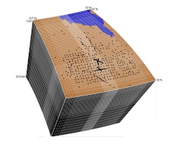
SPREE18 is a regional model of the Superior and surrounding provinces of North America encompassing the Midcontinent Rift System provided as a set of map files in GMT xyz and grd format. The maps are located at different, unequally spaced depths within the upper mantle, with the depth (in km) being part of the file name. This work builds upon the work of Frederiksen et al. 2013.
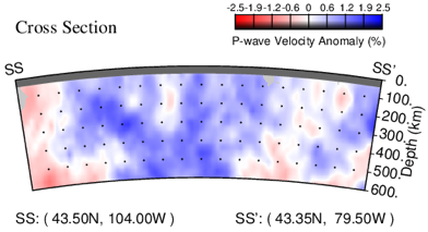
SPREE18 was generated by an inversion of teleseismic P-wave delay times using the code of VanDecar & Crosson (1990). Please read Bollmann et al. 2019 for pertinent details, of which only a few are mentioned here.
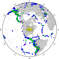
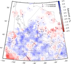
P-wave delay times were measured for 1720 events, using 460 seismic stations from the SPREE, USArray Transportable Array, USNSN, GSN, CNSN, FedNor, FLED, POLARIS, APT-89, TW~ST, and University of Manitoba Seismic networks for a total of 101,233 delay time picks.
Reference:
Bollmann, T.A., S. vanderLee, A. Frederiksen, E.L.G. Wolin, J.S Revenaugh, D. Wiens, F.A. Darbyshire, S. Stein, M.E. Wysession, and D.M Jurdy. (2019), P‐wave Teleseismic Traveltime Tomography of the North American Midcontinent, J. Geophys. Res. Solid Earth, 124. https://doi.org/10.1029/2018JB016627
PDF
Other References:
VanDecar, J., and R. Crosson (1990), Determination of teleseismic relative phase arrival times using multi-channel cross-correlation and least squares, Bulletin of the Seismological Society of America, 80(1), 150–169.
Lou, X., S. van der Lee, and S. Lloyd, AIMBAT: A Python/Matplotlib Tool for Measuring Teleseismic Body Wave Arrival Times, Seismol. Res. Lett., 84, 85-93, doi:10.1785/0220120033, 2013.
Frederiksen, A. W., Bollmann, T., Darbyshire, F., & van der Lee, S. (2013). Modification of continental lithosphere by tectonic processes: A tomographic image of central North America. Journal of Geophysical Research: Solid Earth, 118(3), 1051-1066.